Background Geology of the South Florida Area
Illustrations and objective data courtesy of AMOCO Production Co., Alan B. Shaw (Manager, South Florida Carbonate Project), and Brian F. Glenister (AMOCO Consultant).

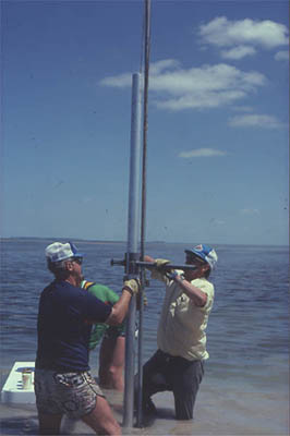
Geologists drilling a core sample.

Text modified after: Amoco Seminar on Stratigraphic Principles, South Florida Phase, 1981, AMOCO Production Company.

The Geography of South Florida:             After (p.11), AMOCO Seminar on Stratigraphic Principles.

    The southern portion of Florida generally has an elevation below 10 feet and has a flat land surface due to coverage by the Everglades and Cypress Swamp. Florida Bay is a triangular-shaped bay that is bounded to the west by the Gulf of Mexico and to the southeast by the Florida Keys. The Keys form a discontinuous island barrier that separates a 4 to 6 miles wide shelf lagoon from Florida Bay. The shelf edge in front of the lagoon is protected by a discontinuous coral reef. The reef complex and lagoon are known as the Florida Reef Tract. A crescent-shaped platform called the Pourtales Terrace is seaward of the Reef Tract and gently slopes from 600 to 1000 feet.


Environmental Characteristics of Florida Bay:          After (p.17), AMOCO Seminar on Stratigraphic Principles.

    Florida Bay consists mostly of a subtropical periodically wet-and-dry climate. The area has a long dry season that lasts from mid-fall to late spring. The rainy season prevails during the summer and early fall each year. The precipitation is approximately 40 inches per year, where about 70% of that rainfall is during the rainy season. The rainfall creates differences in salinity levels of Florida Bay and a north-south salinity gradient. Water salinity levels in the Interior Zone may drop to levels of 20-15°/oo (normal marine salinity is 35°/oo) in mid-winter due to runoff from the Everglades. Salinities in the dry season may rise to 50°/oo in the Interior Zone in July; evaporation may raise salinity values to 70°/oo over shallowly submerged mud banks.

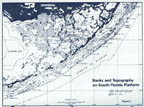
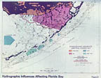
    The shallow waters of the Bay and the Honeycomb network of lime mud shoals (Fig. 1) inhibit water circulation so that at least half of the Bay does not have daily tides (Fig. 2). Salinities are near normal with values of 36 to 40°/oo only in the Zone of Tidal Exchange along the southern and western margins of the Bay. The biota and the sediments that they produce reflect the restricted conditions that prevail over most of the Bay.

Hydrographic Influences of Florida Bay:

    The water of Florida Bay and the Bay biota are derived from three sources: the Gulf of Mexico to the west, the Reef Tract to the south and east, and the Everglades to the north (Fig. 2). In addition to the external hydrographic influences, Florida Bay exerts a certain amount of influence to itself with distinctive characteristics.

    1) Gulf Influence:

    The Gulf has the greatest hydrographic influence in Florida Bay. Gulf water does not have unrestricted access to the Bay because of broad carbonate mud banks in western Florida Bay that restrict diurnal tidal action to the extent that much of central and northeastern Florida Bay is without tides. Significant gaps in the carbonate mud banks allow the Gulf waters to spread across the Bay.

    2) Reef Tract Influence:

    The surface water temperatures for the Reef Tract range from 59° to 91°F. The circulation is open and there is semi-diurnal tide exchange with Florida current. The depth range is 0 to 300 feet and the turbidity (relative amount of sediment in the water) is periodically high in the lagoonal sections.

    Waters from the Reef Tract penetrate Florida Bay mainly through openings between the Keys. In addition, there is some passage through the porous limestones of the Keys themselves. The principal effects of the Reef Tract waters appear in the area southwest of Lower Matecumbe Key (Fig. 1). The Reef Tract influence is greatest opposite the wide gaps in the rock Keys. The waters from the reef tract are also of normal marine type and are subject to daily tidal exchange.

    The reef tract fauna contains many more large species and has greater species diversity than the Bay fauna. The discovery of large corals, Queen Conchs, sea urchins, starfish, sponges, sea fans, sea whips, and sea pens (Fig. 7) all reflect Reef Tract influence in the Bay. Most of the Reef Tract species disappear from the bay a short distance from the Keys.

    3) Everglades Influence:

    Fresh water accumulates in the Everglades between May and October when water levels in Florida Bay tend to be high. When the water level of Florida Bay drops at the end of the year, the freshwater from the Everglades flows southward into the Bay. This cycle suggests that on the northern edge of Florida Bay salinities may range from as little as 10°/oo during the winter outflow to as much as 50°/oo during the late summer. Organisms that can tolerate variable salinity (euryhaline biota) are found on the northern edge of Florida Bay, where organisms that cannot tolerate variable salinity (stenohaline biota) are found closer to the open ocean. The euryhaline biota have low diversity and high abundance, while the stenohaline biota have high diversity and low abundance.

    4) Bay "Influence":

    The surface water temperatures in Florida Bay range from 59° to 104°F. The circulation is restricted with periodic tides occurring only on the boundaries. The depth range is 0 to 10 feet and the turbidity is generally high.

    Overall, the waters of the Bay interior are characteristically variable in salinity. The lower end of the range is apparently not as low as the bordering region of the Everglades; perhaps 20°/oo rather than 10°/oo. However, salinity levels may still rise to levels of 35 or 50°/oo. The low salinity levels are due to the influence of the Everglades, while the high salinity levels are due to excess evaporation over replenishment during the hot summer months. Thus, high salinities are an indigenous Bay environmental characteristic.

    The high salinity levels would not be maintained if there were adequate mixing with either the Gulf or Reef Tract areas. However, mixing does not occur due to sluggish circulation and lack of tides in the Bay interior. Partial stagnation of the water parallels the high salinities and is the second distinctive characteristic of the Bay influence.


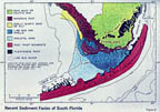
Sedimentary Facies:                           After (p.20), AMOCO Seminar on Stratigraphic Principles.

    Shelly mud is currently being deposited in Florida Bay. Due to the lack of tides, a shallow bottom, and sheltering by the mainland and the Keys, there are not strong currents and high tides unless there is a hurricane. Although strong winds might create agitation levels high enough to produce milky water, the virtual lack of tidal exchange results in resettling of the suspended mud because it has nowhere else to go. However, storm tides during hurricanes can carry mud, not shells, up to five miles inland at the southern end of the Florida mainland. In the interior of the Bay, Hurricane Betsy (1965) locally removed enough mud from the bottom to leave a firm concentrate of shells. These deposits commonly floor many of the "lakes" in the Bay.

    In the marine mangrove swamp along the southern Florida coast (Fig. 5), the salinities range from hypersaline, normal marine, to brackish. The contact between fresh and salt water is drawn by the inland limit of mangroves. These mangroves contribute peat to the sedimentary record. The Everglades consists of marsh and fresh-water environments. Organic muck, non-marine peat, and lime mud with fresh-water biota (charophytes and land snails) are the chief sediment types.

     Reef tract organisms pass through cuts between the Keys and inhabit southern and northeastern Florida Bay. These organisms include corals such as Porites and Siderastrea which occur in patches in association with sponges, sea whips, sea pens, and echinoids.

    Despite water depths being only slightly greater than the depths of the inner Bay, the open circulation and currents do not allow lime mud to remain in this environment. Across from wide gaps in the Keys such as those between Duck and Long Key (Fig. 1), the bottom of the outer Bay is covered by only a few inches of sandy sediment overlying Pleistocene rock.

    The carbonate banks in the Bay (Fig. 1) are commonly covered with mangroves, which mark the transitional environment between marine and terrestrial habitats (Fig. 5 ). Many of these islands have a fringe of mangroves that enclose a centrally located marsh floored with laminated lime mud. Stromatolites and storm-carried lime mud are commonly deposited in these marshes. Surrounding the stromatolites and lime mud are levees of storm-laid coquina. Stromatolites, shell beach ridges, and mud cracks are highly significant of this distinctive environment.


Recent Sedimentation:                        After (p.15), AMOCO Seminar on Stratigraphic Principles.

    Much of the sedimentation in the South Florida Area has been influenced by sea level changes over the last 130, 000 years. The Atlantic Coastal Ridge, which borders Florida Bay, is made of the Late Pleistocene Miami Limestone that forms the highest part of the southern Florida peninsula.

    The Key Largo and Miami Limestones were deposited around 105,000 years ago during the Sangamon interglacial when the sea level stood 25 feet higher than it does now. Other sea level high stands occurred at 130,000 and 80,000 years ago. However, for the last 70,000 years of the Late Pleistocene, sea level was at least 30 feet below its present level. Ice sheets from the last glacial stage began retreating roughly 17,000 years ago when sea level was 400 feet below its present level. The majority of shallow water carbonates found at depths of 50 feet or less were deposited during the last 8,000 years. The sea level in Florida was 12 feet below its present level 4,500 years ago, 6 feet below 4,000 years ago, and 1 foot below 1,000 years ago. Today sea level is still slowly rising.


Molluscan Assemblages:                        After (p.27), AMOCO Seminar on Stratigraphic Principles.

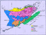
    Each of the four influences (fig. 2 ) that affect Florida Bay also affect the biotic environment. The assemblages of mollusks that form in the Bay or on the Reef Tract are determined by the combination of these factors. Also, changes through time cause assemblages reflecting different environments to lie on top of each other.

    Variations in the abundance and distribution of clams and snails in Florida Bay make it possible to subdivide the faunas into mappable assemblages (fig. 6). The composition and geographic distribution of the groupings was first determined in 1966 by means of a factor analysis, and refinements have been made since that time.

    Samples from within the Bay normally contain 60-80 species. However, near the margins where the Gulf and Reef Tract Influences are felt, the number of types may exceed 100. If the lime muds of Florida Bay were lithified, then it would be these molluscan shells that would be the principal microfossils. They would be the main basis for correlation and would contribute significantly to any paleoenvironmental interpretation.

Click here to view the Molluscan Assemblages of the South Florida Area


Diagrams of the Florida Bay Area

Figure 1

Enlarge image

Banks and topography on the South Florida Platform.
(Modified after Fig.7, p.16, AMOCO Seminar on Stratigraphic Principles)

Figure 2

Enlarge image

Hydrographic influences affecting the Florida Bay Area; divided into environments.
(Modified after Fig.8, p.19, AMOCO Seminar on Stratigraphic Principles)

Figure 3

Enlarge image

Locations of where samples were gathered from.
(Modified after Fig.10, p.22, AMOCO Seminar on Stratigraphic Principles)

Figure 4

Enlarge image

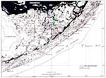
Recent sediment facies of South Florida.
(Modified after Fig.9, p.21, AMOCO Seminar on Stratigraphic Principles)

Figure 5

Enlarge image

Cross section of the Florida Bay Area.
(Modified after Fig.10, p.22, AMOCO Seminar on Stratigraphic Principles)

Figure 6

Enlarge image

Molluscan Facies of South Florida.
(Modified after Fig.10, p.22, AMOCO Seminar on Stratigraphic Principles)


Reef Tract Shoreline

Figure 7

Enlarge Image

Reef Tract Shoreline samples.
(From Dr. Brian F. Glenister's Slide Collection)


Photographs demonstrating shell diversity and abundance

Enlarge image

Picture of some shells displaying low abundance and high diversity.
(From Dr. Brian F. Glenister's Slide Collection)

Enlarge image

Picture of some shells displaying high abundance and low diversity.
(From Dr. Brian F. Glenister's Slide Collection)

Enlarge image

Picture of some shells displaying high abundance and low diversity.
(From Dr. Brian F. Glenister's Slide Collection)

Enlarge image

Picture of some shells displaying high abundance and low diversity.
(From Dr. Brian F. Glenister's Slide Collection)


Return to South Florida Biofacies Project Home Page

Click here for Dr. Brian F. Glenister's department webpage

Last updated on 28 July 2004 - has